


- Named after Chief Joseph of the Nez Perce Indians, the highway follows a historic route of the tribe to flee the US Cavalry.
- Traveling from Cody to Crandall, WY, the 47 miles of road traverses the Shoshone National Forest and Absaroka Mountain Range.
- Be sure to make plenty of stops along the way and experience all the highway has to offer.
Overview
Traveling 47 miles through some of Wyoming’s spectacular high desert and mountain country, the Chief Joseph Byway was aptly named for the Nez Perce’s Chief Joseph, and follows the historic route of the tribe out of Yellowstone and into Montana during their 1877 attempt to evade the US Cavalry into Canada.
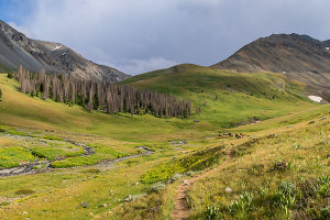
Winding through the Shoshone National Forest, the road traverses deep canyons and high mountains, and includes spectacular scenes such as the one from Sunlight Bridge over Sunlight Creek, the highest bridge in Wyoming. Crossing over the Absaroka Mountains and into the Clarks Fork Valley, this stretch of highway is filled with the forlorn echoes of history, awe-inspiring views, and opportunities to see a variety of animals.
Driving Directions
Also known as WY HWY 296, the road begins in Cody, Wyoming which is situated on the outskirts of the eastern entrance to Yellowstone National Park. The highway can also be accessed from the Beartooth Highway, a 69 mile road connecting Red Lodge and Cooke City, Montana.
Time / Distance
From Cody, the highway travels 47 miles where it connects to the Beartooth Highway, just outside of Cooke City, Montana. From here, you can travel to Red Lodge, Montana or back into Yellowstone via the northeast entrance of the park. Allowing a minimum of two hours for the drive is recommended. Build in some extra time if you plan to make additional stops for wildlife viewing or recreation. Several pertinent stops along the highway include:
Two-Dot Flats: about 16 miles outside of Cody, this old ranch is an excellent wildlife viewing area.
Dead Indian Summit Overlook: 13 miles from Two-Dots flats, this stop showcases panoramic views of the Absaroka Mountains and Sunlight Basin.
Cathedral Cliffs: 13 miles from Sunlight Bridge are the spectacular Cathedral Cliffs where traces of the 1988 Yellowstone Fires can still be detected.
Crandall, Wyoming: The highway ends in Crandall, and this is the only place along the route offering commercial goods. From here, you can return to Cody or continue onto the Beartooth Highway, which is open from Memorial Day through mid-October.
More Info.
If recreation is part of your journey, Cody is known for white water rafting and fishing. Dead Indian Campground and trailhead provide additional opportunities to hike and learn more about the Nez Perce.
As Chief Joseph and the Nez Perce neared Canada, they finally surrendered after the six-day Battle of the Bear Paw in northeastern Montana, just 30 miles from the Canadian border. Yellowstone's Nez Perce Creek is named for this valiant attempt at freedom.
In a dignified surrender speech, Chief Joseph recited, "Here me, my chiefs, I am tired; my heart is sick and sad. From where the sun now stands, I will fight no more forever." Despite promises to allow them to return to their lands, the Nez Perce tribe was forced onto reservations in Oklahoma and Washington.