


- The Clarks Fork is split into three sections, each with a different type of flow
- Recreational opportunities include floating, fishing, camping, hiking, and sightseeing
- It historical ties with the Lewis and Clark Expedition and the Nez Pierce odyssey
Overview
With fishing, camping, and sight-seeing opportunities, the Clarks Fork of the Yellowstone offers recreational activities for everyone. The Clarks Fork flows from Cook City to Laurel, with plenty to see in between, including rapid chutes, a breathtaking canyon, and a slow moving current. It is also known for its deep historical ties with the Lewis and Clark Expedition and Nez Pierce odyssey.
Location and Directions
Upper Clarks Fork
The Clarks Fork Yellowstone River begins just east of the Yellowstone National Park, near Cook City, MT. The Upper Clarks Fork flows downhill to the southeast, cutting a path between the Beartooth Mountains and the Absaroka Range. To reach the Upper Clarks Fork, drive north from Red Lodge on Highway 212 (which turns into the Beartooth Highway). Here, the Beartooth Highway parallels the Clarks Fork.
Middle Clarks Fork
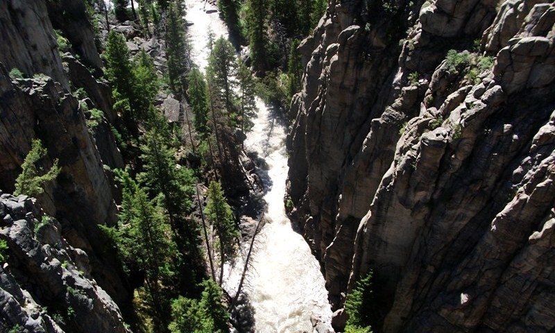
Here, the river continues to gain volume with the addition of several more drainages and run-off. It carves its way through a deep canyon, offering amazing views. To view the Clarks Fork Canyon, access the Chief Joseph Scenic Highway (Highway 296) via Highway 212 after the Beartooth Highway.
Lower Clarks Fork
When it exits the canyon, the Clarks Fork is wider and slower moving, allowing for more access to its recreational opportunities. The river flows past the towns of Bridger, Belfry, Fromberg, and Edgar, eventually flowing into the Yellowstone River near Laurel. The Lower Clarks Fork can be accessed by heading north from Red Lodge on Highway 212, then east on Highway 310. Highway 310 and MT-72 (merges) also parallel the river.
Activities
Floating
The upper and middle part of the Clarks Fork are very swift, and rafting should be left to the expert kayakers who have experience with Class V and VI rapids. However, below the canyon, the Clarks Fork of the Yellowstone opens up into a wide, gently moving river, ranked as a Class I. Whether it’s access to a hard-to-reach fishing hole or just a fun day in the summer sun; rafting, boating, canoeing, and inter-tubing the Clarks Fork is sure to bring you pleasure.
Fishing
Fishing can be difficult in the upper and middle section of the Clarks Fork due to swiftness and difficulty of access. The lower portion, however, offers excellent fishing. Here, the Weymiller Fishing Access Site near Belfry and Bridger Bend Fishing Access by Laurel offer boat ramps for floating and fishing the river. Anglers cast for trout from the shore, by floating, or by wading in the river. The most popular time of year to fish Clark's Fork is after Spring run-off, starting around June, during mid to late afternoons.
Camping and Hiking
Along the Beartooth Highway and Chief Joseph Scenic Highway, there are tons of great places to hike and camp the vast wilderness along the Clarks Fork. The North Clarks Fork trailhead starts on Highway 296 (Chief Joseph), 5 miles from the Highway 212 turnoff. This trail is 8 miles long and allows hikers an easy hike along the Clarks Fork Canyon rim. Accross the road from the trailhead is the Hunter Peak Campground, which offers 10 sites including RV spots, water, restrooms, as well as access to additional hiking and recreation.
Sight-seeing
The three portions of the Clarks Fork offer varied sight-seeing opportunities. The Upper Clarks Fork, along the Beartooth Highway offers views of this fast moving mountain river as it travels through chutes and over falls. The lower portion of the Clarks Fork is a wide slow moving beauty with golden rolling hills and a vast blue sky. Often labeled the most beautiful part of the Clarks Fork, the middle section along the Chief Joseph Highway, travels through the Clarks Fork Canyon. Here, 100 foot cliffs tower up from its banks, offering magnificent sight-seeing opportunities.
Historical Note
The Clarks Fork Yellowstone is named after William Clark of the Lewis and Clark Expedition, of who traveled these same waters over 200 years ago. Also, the Chief Joseph Highway, which parallels the Clarks Fork, is named for path the Nez Pierce Indians traveled as they made their way from their Oregon homeland to the Bearpaw Mountains of northern Montana.
