


- The Absaroka-Beartooth Wilderness offers year-round recreation opportunities, July through mid-September being ideal for summer activities.
- A 700 mile trail system offers hikes and backpacking trips that traverse deep canyons, the Beartooth plateaus, trout-filled lakes, and active glaciers.
- With hundreds of peaks including 29 over 12,000 feet, the AB Wilderness has impressive climbing opportunities.
Overview
As its name implies, the Absaroka-Beartooth wilderness encompasses two mountain ranges including the craggy volcanic Absaroka Mountains on the western side and granitic plateaus of the Beartooth Mountain Range to the east. The Crow Indians who once inhabited the valley called themselves ‘Absaroka’ while the Beartooth range derives its name from its sharp peaks that resemble a bear’s tooth. Part of the Greater Yellowstone Ecosystem, an array of crystal clear streams and lakes, active glaciers, deep canyons, tundra plateaus, and some of the tallest peaks in Montana make this a truly spectacular wilderness.
Locations / Directions
The AB Wilderness is located in south central Montana and Northern Wyoming. Red Lodge, Montana is nestled close to the wilderness and is an ideal base camp for exploring the wilderness. Numerous access points along the Beartooth Highway, Forest Service roads west of US 89 outside of Livingston, and other access roads off I-90 from Billings provide access to the vast wilderness area. The US Forest Service produces an extensive wilderness map. Contact the Gallatin National Forest at (406) 587-6701 or the Beartooth Ranger District at (406) 446-2103 for more information or to purchase a map.
Seasons
Located within the Greater Yellowstone Ecosystem, the AB Wilderness exhibits all the seasonal changes representative of the Rocky Mountains.
Summer: With 29 mountain peaks over 12,000 feet, the elevation as well as latitude produce a short summer season. July and August are typically the warmest months with some years exhibiting warm and dry ‘Indian Summer’ conditions in September and October. Late July to early September are the most ideal times to hike and climb in the AB. Most of the Forest Service roads are open by this time providing better access to remote areas.
Winter: By November, the leaves have long since fallen and there have likely been some snow storms. The winter months stretch from December through March and often linger on through May, producing an average of 500 inches of snow annually. Although the summer months tend to be the most popular for visiting tourists, there are plenty of cross-country skiing, back country ski touring, and snowshoeing opportunities during the white months. Spring tends to unfold slowly as snow fields and swampy wet areas often linger into June.
The most pertinent weather rule of thumb to follow is that anything can happen; planning ahead and being prepared for inclement weather is always advised.
Activities
With just under a million acres, there is no shortage of ways to experience the grandeur of the AB wilderness.
Scenic Drives
From the northeast entrance of Yellowstone, US212 runs through Silver Gate and Cooke City, Montana where the Beartooth Highway begins. The road follows steep switchbacks and runs alongside the wilderness area. From the highway there are numerous lakes, trailheads and scenic overlooks along the 69 mile section as it makes its way to Red Lodge. The road is open from Memorial Day Weekend through mid-October, weather dependent. Allowing for three hours will give ample time to really take in the sights.
Hiking Trails
Combine 700 miles of trail with spectacular waterfalls, 12,000 foot granite peaks, the Beartooth Plateau, active glaciers and sparkling lakes and you get a backpacker’s dream. Plenty of short day hikes lead to some incredible destinations, including:
- From Silver Gate, the 4.8 mile Bannock Trail follows historical bison hunting ground into Yellowstone.
- Another easy to moderate hike outside of Cooke City is a three mile round trip jaunt to the 150 foot Woody Falls.
- Nine miles southwest of Red Lodge is a paved road that leads to the Lake Fork Trail Head. From there, several trails begin including the Lake Fork Trail that follows the Lake Fork of Rock Creek on a ten mile out-and-back hike which passes Silver Falls.
Backpacking
The extensive inter-connecting trail system makes long expeditions into the wilderness area possible for backpackers and horse packing parties. A nineteen mile shuttle hike can be attained by combining the Lake Fork and West Fork trails, which crosses Sundance Pass. With the exception of trail heads and popular day hiking areas, solitude is easily found within the vast trail system. A few of the longer hikes include:
- 12 mile strenuous Aero Lake Trail
- 21 mile Sundance Pass trail and local favorite
- 26 mile Beaten Path that traverses the East Rosebud valley, which many say is one of the most beautiful places in the Absaroka-Beartooth Wilderness
If you don’t have a ton of multi-day miles under your belt, local guide services are available.
Climbing
Beartooth Mountain: Beartooth Mountain, accessed through Black Canyon can be climbed in the winter or summer, although the limited access during the winter makes the already long approach a bit longer.
Granite Peak: Montana’s tallest mountain, Granite Peak (12,799ft), is a strenuous 10-12 mile valley ascent followed by exposed sections of class three and four climbing including an exposed 200 foot section at the top. Though it can be completed in one day, most people opt for two, utilizing a high camp. Ropes are recommended for the climb.
Beartooth Butte: Beartooth Butte, accessed from Beartooth Lake off the Beartooth Highway is an easier 2-3 mile climb that promises spectacular views of the top of Montana. The top of the butte is highly exposed, and storms often move quickly, a good reason to constantly observe weather conditions.
Fly Fishing
The Absaroka Wilderness is well known for its spectacular lake fishing. Cutthroat, Rainbow, Brown, and even the occasional Golden trout are all found in numerous lakes and streams that offer blue ribbon backdrops. Knowing where to fish is key, as some of the lakes do not carry fish due to winter kill. Hiring a guide, stopping in a local fly shop, talking with (bribing) the locals, and purchasing a guide book are all recommended for optimizing your chances of landing a good looking fish.
More Info.
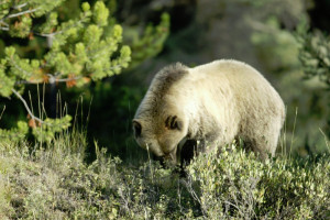
A multitude of designated campgrounds and informal campsites provide unlimited opportunities for camping. As the AB Wilderness houses many a grizzly bear, appropriate precautions should be taken with regards to food storage.
The AB Wilderness is a huge place and therefore a map is always advisable for treks of more than a couple of miles. With open vistas and grand overlooks, the AB is a great place for off trail hiking, as long as you have your trusty map.
Claims exist that Montana is home of the largest mosquito in the lower forty-eight. Snow melt, geographic ‘potholes’, and boggy areas create some serious mosquito and fly conditions. Repellent of the DEET nature is recommended.